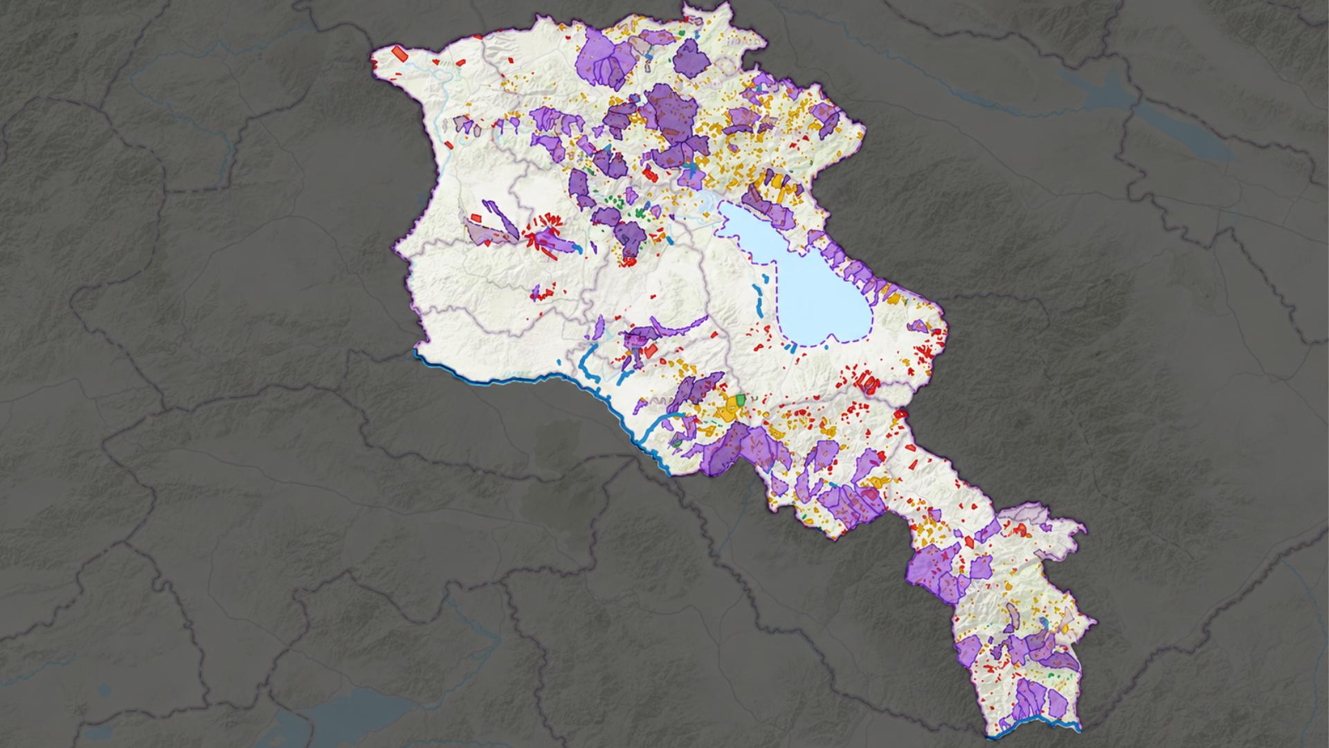
For years, climate change in the South Caucasus has felt like an abstract threata series of distant warnings about rising temperatures and shifting weather patterns. But in Armenias mountainous terrain, those warnings are rapidly materializing into tangible economic disruptions. Droughts parch agricultural valleys, flash floods destabilize rural infrastructure, and unseasonal frosts threaten harvests. In a country where temperatures climbed 1.23 degrees Celsius between 1929 and 2016, the climate crisis is no longer a distant projection; it is an active economic threat. By 2100, scientists project that warming could skyrocket by a staggering 5.6 degrees Celsius. This rate of warming outpaces global trends, with Armenia heating up 35 to 40 percent faster than the global average warming rate. Recognizing that environmental volatility directly translates into financial instability, the Central Bank of Armenia (CBA) has stepped outside the traditional boundaries of monetary policy. In a strategic collaboration with the Asian Development Bank (ADB), the CBA officially unveiled a pioneering initiative: the Climate Risk Map of Armenia. This highly detailed, micro-data-driven platform transforms how the country measures environmental vulnerability, turning complex satellite imagery into an actionable blueprint for financial institutions, urban planners, and agricultural sectors. A Nation on the Climate Frontline Armenia's unique topography makes it exceptionally vulnerable. In global metrics, the country ranked 52nd out of 181 nations on the 2022 climate vulnerability index. The structural and environmental threats are diverse, severe, and deeply intertwined with the landscape: When a country faces this level of geographic volatility, the macroeconomic chain reactions are severe. By the 2070s, potato yields could decline by 21 percentparticularly crippling the Shirak and Syunik regionswhile grape yields in the vital Ararat Plain could drop by 20 percent. Furthermore, due to severe heat stress, labor productivity during peak months could fall by 20 percent by the 2050s. Granular Data for an Unforgiving Landscape Traditional country-wide climate profiles are simply too broad to protect a local community or evaluate a specific real estate loan. To solve this, the newly launched platform utilizes advanced micro-data to map environmental hazards at the settlement level. The calculations span an impressive 1,001 entries, meticulously indexing information across individual villages, communities, and provinces. To give users a holistic yet highly specific view, the CBA structured the interactive system into three core pillars: Powered by Global Satellite Intelligence & Multi-Institutional Research Building a framework of this magnitude required merging world-class earth observation technology with rigorous, multi-institutional climate science. The CBA did not build this platform in a vacuum. The underlying data architecture is a synthesis of foundational findings from the World Bank and ADBs 2021 Climate Risk Country Profile, the International Monetary Funds (IMF) 2022 assessment on Fiscal and Macroeconomic Risks, and Armenia's own Nationally Determined Contributions (NDCs) for 20212030. Under the NDCs, Armenia has committed to an ambitious goal: reducing its greenhouse gas emissions by 40 percent relative to 1990 levels by 2030. Achieving this requires a massive re-allocation of capital toward climate-resilient projects. To make those capital decisions accurate, the underlying mapping data was compiled and updated using a sophisticated mix of international and orbital assets: From Climate Science to Capital Allocation While environmental mapping is typically the domain of scientists, the CBAs tool is explicitly engineered for financial institutions. When labor productivity drops due to extreme heat stress and staple crops face double-digit declines, the baseline assumptions of traditional banking fall apart. Collateral values shift, risk profiles change, and traditional repayment schedules are disrupted. By cross-referencing this tool with their own client databases, commercial lenders can definitively identify zones that require more detailed risk assessment before capital is deployed. A bank evaluating a vineyard loan in the Ararat Plain or an agricultural expansion in Syunik can now instantly check the investment against localized drought, heatwave, and landslide probabilities. Beyond the boardroom, the map is poised to become a vital public asset. The CBA notes that its open framework will benefit municipal infrastructure planning, guide climate-smart agriculture investments, assist in water resource management, and provide researchers with an uncommonly detailed baseline dataset. Armenias Central Bank is demonstrating that monetary stability in the 21st century cannot be separated from environmental reality. By putting these climate maps directly into the hands of underwriters, insurers, and macro-planners, Armenia is working to ensure that as its climate warms, its financial ecosystem remains structurally sound. The Cost of a Warming Caucasus: How Armenias Central Bank is Mapping Climate Chaos Climate change is no longer just an environmental issue in Armeniait is a major macroeconomic threat. Armenia ranks fourth globally in average annual temperature volatility, and between 2000 and 2017, the annual duration of droughts expanded by 33 days. Under a high climate volatility scenario, IMF modeling indicates that Armenia's public debt-to-GDP ratio could swell to 62 percent by 2072, compared to a baseline of 47 percent. Identifying High-Risk Hotspots The assessment revealed that 74 settlements exhibit "high" vulnerability. The risk is heavily concentrated in two regions: The COP17 Connection: Mapping Risks to Fuel Biodiversity Action The CBAs climate risk maps show exactly where the dangers are, while Armenias national biodiversity targets under the UN Convention on Biological Diversity (COP17) outline the concrete steps the country is taking to address them. Armenias action plan for 20262030 establishes aggressive, measurable targets to rebuild resilience in the exact areas highlighted by the maps: By putting these detailed climate maps into the hands of underwriters, insurers, and macro-planners, Armenia is connecting environmental science directly with capital allocation to ensure its financial ecosystem remains structurally sound. (The program was implemented with the support of the Asian Development Bank. The maps are available HERE.)
Already in English.
3 full-article translations/day — headlines & summaries always free. Create free account for 25/day
Mapping the Unseen: How Armenia’s Central Bank is Quantifying Climate Risk for the Financial Future
By putting these detailed climate maps into the hands of underwriters, insurers, and macro-planners, Armenia is connecting environmental science directly with capital allocation to ensure its financial ecosystem remains structurally sound.
Comments
No comments yet — be the first to comment.
More from Hetq

Տեղի է ունեցել Նիկոլ Փաշինյանի և Վլադիմիր Պուտինի հեռախոսազրույցը․ վարչապետը ՌԴ նախագահին շնորհավորել է ծննդյան օրվա առիթով
Hetq / 30 minutes ago
Ֆասթ Բանկը պարզաբանում և հերքում է մի շարք պնդումներ
Hetq / 44 minutes ago
«Հետքի» հոդվածի հիման վրա կայացվել է Սևանա լճի ազդեցության գոտում գործող ասֆալտբետոնի արտադրամասի գործունեության կասեցման որոշում. ԲԸՏՄ
Hetq / 52 minutes ago
Սպասվում է կարճատև անձրև և ամպրոպ
Hetq / 1 hour ago
Related coverage

Արթուր Դանիելյանը ձերբակալվել է՝ դատարանի կալանքի ներկայացվելու համար
Factor.am / 2 hours ago

2027 թ․ հունվարի 1-ից սոցփաթեթի ծրագիրն ավարտվում է․ փոփոխություններ և նոր հնարավորություններ. ՈՒՂԻՂ
Factor.am / 2 hours ago

ՈւՂԻՂ. 2027 թ․ հունվարի 1-ից սոցփաթեթի ծրագիրն ավարտվում է․ փոփոխություններ և նոր նարավորություններ
News.am / 2 hours ago

2027թ. հունվարի 1-ից սոցփաթեթի ծրագիրն ավարտվում է. փոփոխություններ և նոր հնարավորություններ․ ՈՒՂԻՂ
A1plus / 2 hours ago